Thursday, July 9, 2015

We walked.

Lightning, when heard from extremely close range, sounds nothing at all like the boom-crashhhhh of lightning at safer distances. There's a bright flash accompanied by ten 12-gauge shotguns firing all at once, and in our case, a shower of sparks emanating from an electrical transformer mounted on a power pole just across the street. 

Luckily, we were safe inside a bus, but it was a startling reminder that lightning in the mountains is a genuine threat. And here we were on our way higher up the mountain to regain the trail after our short break in Mammoth. 

We made it back to Red's Meadow without further excitement, and after a chocolate milkshake at the small diner we headed off down the rain-soaked trail. 

Shortly we arrived at Devil's Postpile, a geologic feature that was only barely saved from miner's dynamite by its protection as a national monument.
 

A few miles later we found a suitable campsite along the middle fork San Joaquin River. We fell asleep to the rush of the water, our equipment safely stowed from the promise of overnight storms. 

We had one more pass to climb before crossing into Yosemite National Park and what we hoped would be an easing of the strenuousness of the trail. We had no idea how wrong we were. 

An afternoon thunderstorm chased us over Donohue Pass at record speed, with Alyssa leading the charge across the exposed summit before the very dark storm clouds closed in on us. With barely a pause at the top to regain our breath, we charged down the other side, and just in time. As we reached the tree line the steady rain turned to a torrent of dime-sized hail. We sheltered under a paltry stand of Foxtail Pines until the downpour passed, then carefully picked our way down the over the slickened rocks. Fighting the usual battle against the mosquitos, we ate dinner and tucked ourselves in to the sound of light rain on the tent punctuated by the lingering crashes of distant thunder.  

The ten or so miles to our resupply at Tuolumne Meadows the next morning flew by as the entire route was a nearly level stroll down a wide meadow-filled valley. 


The hiker and tourist circus that was the Tuolumne Meadows Store was a startling change from the perfect solitude of the high Sierra, and we found an unoccupied picnic table far enough away from the crowds to keep us happy. The post office staff was apparently sick of the circus as well and had designated 3:00 pm as the official hiker box pickup time -- Don't even bother trying to get your box at other times. With two hours to kill I requisitioned a box of Cabernet, a box of Ak-Mak, and a wheel of goat cheese to enjoy in the meanwhile. Pleasantly lubricated by the wine and warm sun, we collected our box at the appointed hour, divided up the goods between us, and departed with another PCT couple also on their way north. Our goal that evening was Glen Aulin campground, some six miles on. 

Again chased down the trail by an imposing thunderstorm, we made excellent time over the glacial-polished granite and past two magnificent waterfalls. That night the rain on the tent was heavier, but had relented by the time we lazily readied ourselves the next morning. 

We left later than normal, and with less enthusiasm than normal. The trail steepened, then steepened some some more. Morale plunged, then plunged more. Luckily the rain left us alone that day, as through the two vertical climbs and equally vertical descents we managed only fourteen miles that day. The next day was the same routine - straight up the side of a steep valley, then straight down the other, followed by straight up the next. Morale dropped even lower. We each began making plans to get off the trail as soon as possible. Despite the magnificence of the surroundings, we were too tired to care, and in any case too preoccupied looking at the trail so as not to break a leg, to ever look up and enjoy the scenery. I made a fire on the second night to keep away the swarms of mosquitos. This was only partly successful. After three days of this agonizing, muscle-torching routine,  we made a final steep descent into a wide valley, where we turned northwest at a creek to follow the valley gently uphill for six miles past Glen Meadows and Dorothy Lake, and out of Yosemite National Park. 

As soon as we passed into the Herbert Hoover Wilderness of the Toiyabe National Forest, the topography changed. Gone were the glacial-carved granitic domes and valleys of Yosemite. In their place were ruddy volcanic peaks, ridges, and wide-open valleys. We made another bug-ridden camp at Lake Harriet, where we cooked and ate in the tent; neither of us having any more patience for the mosquitos. 

That night we resolved to hitch out to Bridgeport at Sonora Pass. We were both approaching terminal burnout, and were beginning to ask ourselves what the point of all this was. When you start to ask that question, then what's the point? It was time for some real R&R so that we could retake the trail with fresh eyes and really enjoy the journey that we were on. 

Just resolving to take a step back improved our moods dramatically. The next morning we took our sweet time eating breakfast and actually enjoying the campsite and lake. We finally started hiking after ten in the morning, but who cared? We lunched by a creek as very dark clouds began gathering to the east, which was fine with me as long as they stayed to the east. 

The trail led us steadily (but not steeply) up, and soon we came to a junction above the tree line - one trail switchbacking up Emigrant Pass and our trail switchbacking up to Leavitt Peak. We attacked the old jeep road with a crisp pace and were soon awarded with an incredible view of deep violet storms to our East contrasting with the blue white and grey of the clouds and peaks to our south. 


Up we climbed, then leveled and followed the 11,000 foot ridge as it undulated northward. To our left the mountain dropped off steeply to a valley and lake some 1,500 feet below. To our right the hill rose for twenty feet before dropping precipitously about eight hundred feet to Leavitt Lake. This section could easily be fatal in a heavy snow year.  

Thankfully, the snow huddled only in small patches and the storms remained safely crackling off to the east. 

At long last we reached the descent to Highway 108 and Sonora Pass. We had hoped to hitch into Bridgeport that night, but by the time we reached the road there was almost no traffic daring the pass in the darkening evening. The one driver who stopped turned out to be lost, so we gave him directions and sent him on his way. We decided we would have better luck in the morning. 

We pitched our tent in the deepening afternoon, spirits again high that we would soon be enjoying a hotel, showers, and real food. As we finished dinner the setting sun broke under the overcast, illuminating the massive thunderstorms in the most spectacular display I might have ever seen. I was suddenly very grateful that we hadn't found a ride, as we might have missed this bit of magnificence. 

After a few days off in Bridgeport and South Lake Tahoe, we'll be recharged and ready to take on the next month of hiking, one step at a time. 


Tuesday, July 7, 2015

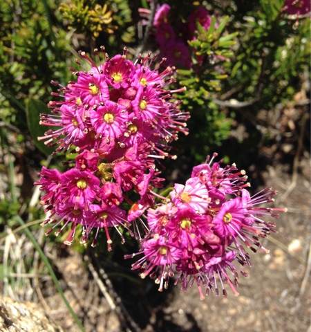
Sierra Wildflowers

I could write volumes about how these little beauties saved me from a multitude of fatigue-induced bad moods, but instead I will just offer you their beauty. Hopefully they will bring you the same cheer and resolve that they did for me.


Tuesday, June 30, 2015

Passes and Mosquitos

I know we've only been hiking for seven weeks and four days, but to me it seems like nine weeks and five days. The first day back on the trail after taking a break in Lone Pine seemed like a week and the second day seemed like five days. And the third day seemed like a week again and the fourth day seemed like eight days. And on the fifth day we stopped at Muir Trail Ranch and that seemed just like a day, and then we went back to hiking and later on the sixth day, in the evening, after climbing Selden Pass, that started seeming like two days, so in the evening it seemed like two days spilling over into the next day and that started seeming like four days, so at the end of the sixth day on into the seventh day, it seemed like a total of five days. And the sixth day seemed like a week and a half.

Thank you, Navin.
http://youtu.be/vkVzspuCkxg

Basically the passes, they kept comin', and every day started blurring into a series of steep granite steps. Then the mosquitoes started up, and they kept comin', and every day blurred into one awful buzzing-in-your-ear, self-slapping, midnight-scratching-in-your-sleep session.

But indeed, there was more to this last stretch than Sisyphean boulders and Hadian blood suckers. When we left civilization, we had the formidable task of hitching UP into the mountains... on a Monday morning, on a peaceful street in sleepy town Independence, when the weekend adventuring is over and normal people are at work. We despaired as the hours passed, our journey halted just before the revered Range of Light just because we couldn't catch a damn ride. As we sweated in the low elevation Owens Valley summer heat, a van careened around the corner and stopped right in front of us.
"Need a ride up the hill?" the driver asked through the passenger window past a bearded hiker. 

With great relief, we stuffed ourselves into the Econoline around and on top of six other hikers, their gear, and a dog strewn haphazardly around the benches. We squeezed one more hiker in a mile up the road and wound our way up away from Independence towards the Onion Valley. 

After refilling our water at the trailhead and adjusting our packs, we set off back up Kearsarge Pass. The climb went by quickly, fueled by an extra cup of coffee and a large breakfast at the Alabama Hills Cafe in Lone Pine that morning. As we crested the summit, the Kearsarge Lakes came into view, reflecting the 12,000 foot Kearsarge Pinnacles behind. Down the other side we skied on the loose, rocky trail back to the PCT/JMT junction, where we turned right (north) to tackle the second 12,000 foot pass of the day. Little did we know that this was our new daily routine for the next week.  

High knees! Up and up and up we climbed Glen Pass, around or over large boulders placed regularly in the trail to arrest trail washout (and our momentum). When we crested, we were rewarded with the Rae Lakes a million deep knee squats below us. Down and down and down we switch-backed steeply over a rough rocky path, past electric blue tarn lakes sitting high up in the glacier carved bowls. The grade lessened as we crossed and recrossed snowmelt streams flowing through tundra-like meadows devoid of trees but teeming with marmots. 

Below the tree line we came upon a small herd of deer grazing just off the trail. They cautiously watched us but didn't leave their grassy patch, allowing us to observe them from a stone's throw away. A young six-point buck still had velvet on his antlers. While we whispered about their lack of fear, the buck
unceremoniously showed us who was boss by squatting and pooping while eyeballing us. 


See him? No?


Now? Yeah. Insolent. We moved on. Clearly we were challenging his manly deerhood and I for one wasn't willing to get chased down a rocky slope by a young, insecure buck.

Farther down the path, just past Upper Rae Lake, we saw our first black bear of the trip. He/she rolled contentedly in a wild currant bush, munching happily. We were close enough to hear the leaves and twigs crunching. Seeing a bear eating its natural food source nailed home the point of our heavy and unwieldy bear canisters. Our food stays locked up tight and the bears don't become human food nuisances that need to be put down. I haven't complained about the bear canister requirement since then. We made camp at Middle Rae Lake, enjoying the colors and shadows the sunset cast on the surrounding peaks. As we ate dinner, the abundant trout made rings in the lake, catching their own suppers.

Pinchot Pass was our challenge for the next day, which started with a pleasant descent down the valley along a rushing stream. We even got to pass over a suspension bridge. Capacity: one hiker at a time. I could imagine snapping crocodiles in the water far below. 


That's where the pleasantness stopped. The trail turned sharply uphill and the next seven miles were a steep ascent up the same knee-high granite steps under an unrelenting sun to the crest of Pinchot Pass. The resulting view inspired a single picture. Maybe it was exhaustion, maybe it wasn't the grandest pass, but we agreed it worth only a cursory check mark. 


Wednesday dawned clear and sunny, giving us flat bright light not conducive to pictures. Pinchot had left us feeling unenthusiastic. Another day, another pass. Next up: Mather Pass, another 12,000 foot barren notch in the snow-dotted peaks. The only relief was the promise of a gentler ascent and descent. When the grandeur of our surroundings failed to motivate our heads up, I noticed myself taking greater note of the little
things at my feet - namely, wildflowers. Amidst the melting snowmelt streamlets, they boldly punctuated our path with colorful and delicate blooms. The variety and cheer were decidedly noteworthy in an environment that offered little else but harsh bright light and jagged rocks.

Another constant that provided some interest was the water. Oh, the water! Long gone were the days of water reports and carefully calculated miles versus liters. Now we had abundant snowmelt and more streams, creeks, rivers, and waterfalls than we imagined possible. The granite was streaked black from the years upon years of runoff. We constantly had to pick our way through muddy trails and across rivulets that accumulated to greater force in the valleys below. 


From Mather Pass, we descended all the way down to 8,000 feet. We passed a NPS crew hard at work on the trail - pick-axes, rock hammers, and all. Our path down was dotted with Aspen groves, their bright green leaves in contrast to the dark green conifers. Their shimmering shade soothed our taxed moods. We enjoyed the level path along the South Fork King's River until we hit camp.

Even a non-outdoorsy person knows that awful buzz. It's a certain timbre of whine in your ear that gets your lizard brain to start madly slapping at your head before you've even processed why. Mosquitoes swarmed us as we tried to set up the tent. They swarmed as we tried to eat dinner by spooning up each mouthful under our head nets. They swarmed into the morning, urging on our lazy routine. We were suddenly inspired to climb to higher elevations. Muir Pass lay beyond, and hopefully fewer mosquitoes.

As we labored uphill, we debated the potential merits of a pass named after John Muir. With such a namesake it had to be the grandest pass of them all. 

We were not disappointed. The mosquitoes disappeared and we happened upon a lake filled with mountain yellow-legged frogs and tadpoles. The ascent was easy and offered in stages. As we crested each high point, a new one offered itself further on. The fake-outs were tempered by stunning snowy peaks, fresh snowmelt streaming beneath our rocky path, and glacial blue lakes. When a stone hut came into view, we knew we had made it.


Built in 1931 as a shelter to those crossing the exposed 11,955 foot pass, it was a beacon as we huffed and puffed our way up. In an environment that constantly reminded us of how small and fragile our lives are, this hut represented a rare example of human persistence amidst total wilderness.

We stopped for lunch at the hut, the marmots unusually bold in their investigations of our food. "Keep wildlife
wild!" (no matter how cute their noses wrinkle or round little bodies trundle across the ground).

Some clouds gathered, offering exceptional drama to the peaks and lakes as we descended. We had anticipated afternoon thunderstorms, typical to the Sierras in the summer, but hadn't yet experienced any on this trip. Jan pointed out some clouds off to the east, proclaiming "I don't like the look of those one bit" with Drees-level caution. While I admired the atmospheric beauty and took pictures, he ushered us down the hill to less-exposed territory. 


As we passed yet another glorious lake, we encountered some more wildlife. This time, a long-tailed weasel bounded across a meadow, sneaking from burrow to burrow while Belden's ground squirrels stood on their haunches to chirp-chirp-chirp warning alarms. Less than a half mile later, we were greeted to a Sooty Grouse and her brood of eight chicks, pecking across a small clearing. The soft coos and squeaks audible in the quiet late afternoon were all we needed to pack it in. This day wasn't going to end much better!

As we put down one last mile to a good campsite, I snapped a photo that perfectly captured the Sierra. 


We camped next to the rush of water and the buzz of more mosquitoes. In the morning, we admired the relentless effort of ants clearing dead mosquitoes from our tarp. While we ate our morning gruel ("oatmeal du jour, my sweet?" *grunt*), we freely slapped each other, cursing the nonstop assault. We packed up camp in a hurry and hiked to our next resupply: Muir Trail Ranch. We had heard that MTR wasn't hiker friendly, but held out hope for a shower in addition to our resupply bucket ($70 to carry that shizz in on a mule!). 

We arrived to get our bucket under a paltry tarp for shade and not much else. We envied the Ranch guests moseying down the path in flip flops and towels to their private hot springs. There were additional hot springs up the trail, but five days of intense hiking doesn't make steaming in your own filth without a shower first particularly appealing. We stocked up our bear canisters and hiked on, dirty and disappointed.

After some angry (motivated? determined?) steep switchbacks, I couldn't take the smell of myself anymore and vowed to get into some form of water asap. Two miles and one interrogation later ("Where the hell is that creek we were supposed to hit in two miles?!" "We've only gone a mile and a half." "WHAT?! Goddammit!!!"), we hit Senger Creek and as soon as we could get our packs off, I was down to my skivvies and in the water. Cold be damned, I splashed around in some manic form of bathing. Jan followed suit. 

Any semblance of cleanliness goes a long way, because that night's mosquito slapfest seemed almost charmingly rustic. Jan built one of the few campfires we have had on the trail and proclaimed the smoke as anti-mosquito while I slapped his head and proclaimed, "Sorry, mosquito." I went to bed early, enjoying feeling clean. 

The next day was Selden Pass, made easy by our switchback assault the afternoon before getting the majority of the ascent done. When we descended down the next canyon (52 switchbacks down? 57? Who can remember?), we were greeted by a grove of thick, old aspen. We passed some odd muddy mounds in a clearing, water bubbling out the tops. Mono Creek was just around the corner, as was our camp, made at the base of our next pass.

Silver Pass was the one that broke me. Only a couple miles into those huge granite steps, my legs screaming at me to stop, I listened. I sat down on a boulder, my chest heaving for air, and my eyes welling with tears. Jan sweetly sat down next to me and put his hand on my leg while I cried, not much needing to be said. We were both tired. After the tears dried, I got back up and continued walking, Jan patient behind me.
Solid gray clouds had been hanging overhead all day. Slower than usual, we summited the pass just as the rain began. We ate our wet snack silently, enduring what was starting to feel like a grind. As the raindrops lightened and stilled, we put our packs back on and I vowed to make up my painfully slow ascent. I borrowed Jan's iPhone and earbuds, put on some music, and blasted down the other side. 

We were stymied only ten miles into the day by an unrelenting rainstorm. I was soaked (having declined to don my rain gear thinking that the storm would be brief) and the lightning started up just as we began ascending the next pass. We opted to make an early wet camp rather than get turned into shish kebabs. Thusly we spent a miserable afternoon, wet inside our wet tent with our wet belongings. It was a long night. 

The short day meant an early rise the next one, with my internal alarm getting me up at 4:51am. I pumped water in the dark, the trees still dripping. We had breakfast in the tent to avoid the mosquitos hellbent on their own breakfast and broke camp by 6:30am.

It was our eighth day straight on the trail and we still had two more days to go until our next resupply at Tuolumne Meadows. Unless... Unless! We could get off the trail early at Mammoth. We had heard that there were shuttles running from Red's Meadow. Coincidentally, Red's was only 17 miles away, an easy day's walk with no pass to climb. That meant we could have proper showers and food before the day was out. There was hardly a discussion to be had!

After a climb to Virginia Lake, a girl in pink thermals and a puffy down jacket gave a shout as she ran down a small slope to greet us. The impossible! It was my friend Melissa, hiking the JMT, and we had actually crossed paths. We hugged and commiserated about our respective trail experiences thus far. It was a cheerful boost to our day and made our further ascent to Purple Lake easy. Friendship, sunshine, and the promise of a beer made for lighter, quicker footsteps. We hit the bottom of a broad canyon that had experienced a forest fire, the blackened tree stumps ringed with young trees as the forest sprouted anew. Dark clouds gathered behind us and thunder spurred us on more quickly to Red's Meadow. As soon as we set down our packs, the thunderstorm arrived and we gratefully sheltered under a huge White Fir. 

We purchased a couple beers as we waited for an available shuttle. All the immediate ones were mobbed with day hikers escaping the rain. We idled with some fellow PCT hikers, trading trail gossip and town recommendations. 

Finally the day hiker crowds thinned and we squeezed onto a shuttle. One night off the trail and we'd be back, Yosemite bound, with a single step.


Sunday, June 21, 2015

The High Sierra! (For real, this time)

The morning of Saturday, June thirteenth saw me waiting on the platform at Simi Valley station for the next northbound Coast Surfliner. The dry Santa Susanna Hills looked the same as the last several hundred miles of dusty chaparral that we had been slogging through. Soon, however, that would be only a dim memory. On Monday when we returned to the trail we would start at 9,000 feet in elevation and would rapidly climb to over 10,500 feet, there to remain for the next hundred miles.

The train arrived on schedule and the dusty view turned to the cool farmland of the Santa Clara River floodplain, and soon I was catching glimpses of the Channel Islands through thick haze. 

The wedding that afternoon was a beautiful event under soaring Sycamore trees in the company of as warm, intelligent, and talented people as anyone should have the privilege of knowing. 

The open bar, on the other hand, was a blessing that evening and a curse the next morning as Alyssa and I roused ourselves out of just a couple of hours of lousy sleep. 

My brother Bart, home for a few weeks from college, volunteered to drive us back to Kennedy Meadows, so in dad's car we sped over I-14 past Vasquez rocks, straining to catch a glimpse of the trail we had hiked an eternity of three weeks ago.  

As we sped into Lancaster the temperature soared into the triple digits, finally topping out at 108 degrees. We turned off the highway and climbed the narrow mountain road toward Kennedy Meadows as the air steadily cooled into a more manageable eighty-two degrees. That evening we made our first campfire of the trail and drank beer while looking at the stars. When we climbed into our tent that night it was like returning home. 

Perhaps it was the five days off, perhaps it was the altitude, perhaps it was the drinking like you're 25 when you're 35, but the next day was a struggle as the trail wound up into the southern Sierra through a thin pine forest. The dust was dustier, the sun was hotter, and our packs were heavier, but we pressed on. 

The Manzanitas, our constant companions thus far, hugged lower and lower to the ground until they disappeared into it altogether. Goodbye chaparral. 

We passed through or around several of the large meadows that dominate the valleys of the southern Sierra. Soon we reached a pretty steel bridge over the South Fork Kern river and unshouldered our packs to nap and snack in the shade along with twenty or thirty other hikers. Swallows that had made their mud nests under the bridge sallied back and forth catching their lunches. We managed another five miles of steady climbing that afternoon before camping next to a huge fallen Jefferey Pine just past the Olancha Peak trail junction. 

The next day we resumed the climb over a ridge and into another meadow valley. We stopped for lunch at Gomez Meadow where a solitary eight point buck grazed, unconcerned. Unseen fighter jets thundered far overhead, breaking the otherwise perfect quiet of the warm afternoon. After lunch the trail pitched upwards to climb steadily for three miles, and two thousand feet later we regained the Pacific Crest for the first time since before Kennedy Meadows. The eastern slopes dropped precipitously down to shimmering Owens Valley seven thousand feet below.


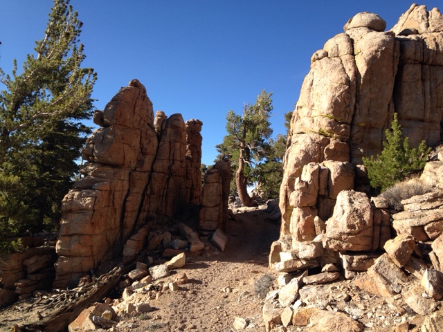
The trail mercifully flattened out (only because there was nowhere else to climb at the moment) and, after passing through an ancient granite "gate" descended to a broad gravely saddle where we made camp for the night at 11,000 feet. 


Morning dawned chilly, but warmed up as soon as the sun peaked over the eastern crests. We enjoyed the views from our high saddle and again set off down the trail with considerably more spring in our steps than the previous two days. Perhaps we were finally acclimating to our new packs and the altitude. 

The discussions that day revolved around the logistics of adding a day to this section to summit Mt. Whitney with our available supplies. The high Sierra is considerably more remote than any of the previous 700 miles. Resupply is not as easy as simply hitching out at the nearest road - the nearest road is often eight miles away and over a 13,000 foot pass! 

We watered at Diaz Creek where tiny alpine hermit crabs with shells made of glued sand grains scurried along the bottom of the shallow creek. 

The trail climbed away from Diaz Creek and over several small ridges where the formerly distant peaks of the high Sierra - grey jagged teeth far off on the horizon for the past two weeks - now seemed close enough to touch. Steadily we ascended toward a massive bald peak, the Lodgepole and other pines giving way to gnarled Foxtail pines as we approached the timberline. We paused at Chicken Spring Lake for a rest, our first Sierran Lake and only the third lake of the entire trail so far. The still blue water reflected the steep glacier-carved bowl it filled. Above, the omnipresent fighter jets burned up our tax dollars joyriding over this most scenic landscape. I couldn't blame them one bit -- I would be doing the exact same thing if given the opportunity. 


We crossed into Sequoia National Park at 11,200 feet and camped in a small meadow as the sun set behind the craggy range to the west.  

After our discussions of the previous days, we decided that it was possible to summit Whitney and make our scheduled resupply without starving to death. To this end we set off the next morning, descending to cross a large creek where we rested in the shade while a mule skinner coaxed his laden animals across and up the opposite bank. 

Again the trail climbed above the timberline and then rapidly descended a rough and bouldered set of switchbacks into a steep-sided granite canyon. Exhausted by the climb and the subsequent treacherous descent, we took a short break under a huge Foxtail pine before resuming the trail as it climbed the canyon under ever more majestic peaks. Within a mile we came upon a sign marking the Whitney Spur trail, which we followed past a babbling brook filled with so many trout you could walk across on their backs without getting wet. 

The trail followed the stream into the most picturesque meadow either of us had ever seen. Birds sang in key with the brook and the mountains gazed on benevolently from the impossibly blue skies. A pair of deer grazed completely unafraid only feet from the trail. Disney could not have composed a more idyllic scene.

The trail climbed steadily and at times steeply towards the high peaks of the Whitney group. The feeling of the vastness of the mountains is almost impossible to describe in words and is even more futile to capture accurately in a picture. We were as joyful as we had been in days, smiling at every step and turn of the trail, each moment a gift that made the physical effort easy.


Up and up we walked, deeper into the great glacial valley surrounded by these massive peaks. Soon even the Foxtail pines couldn't take the altitude and disappeared, leaving only hardy meadow grasses and moss to add splashes of green to the immense grey and blue panorama. 

Guitar Lake teemed with would-be summiteers and a fairground of tents. Seeking a more serene setting for our camp, we followed the trail a little higher over then next rise and were rewarded with a pristine lake and meadow completely to ourselves. Below, the circus at Guitar Lake was close enough to be audible, but for some reason not one other person had thought to hike another ten minutes up the hill to escape the cacophony.  

This was our highest camp yet at 11,700 feet, and by far the most scenic. We even had an infinity pool overlooking distant sawtooth peaks. 


Being more possessed than my wife of that spark which drives people to summit high peaks, I would be making my summit attempt alone. I awoke at 4:30 the next morning and escaped the siren call of my warm sleeping bag into the chill predawn air. The headlamps of sunrise summiteers bobbed along the switchbacks thousands of feet above as the first gray of dawn lighted the sky. After a hearty breakfast and coffee, I set off up the trail with a small daypack. My steps were light and fast without fifty pounds on my back, but I soon found myself winded by the thin air and the steep switchbacks. After a mile the grade slacked a little and I found a comfortable pace. Higher and higher I climbed up the east face of the Whitney/Muir crest. Soon I was looking down on the peaks of Mt. Hitchcock, which that morning had seemed to tower impossibly over the campsite. The summit of Whitney was still out of sight and two thousand vertical feet away. Far below, the Hitchcock Lakes were black bottomless pools. 

I rounded a switchback and paused to catch my breath just as the first sun rays kissed the top of the distant sawtooth peaks. I lost my breath all over again. The monumental grandeur of the vision was like looking into the face of God, and all I could do was laugh like a fool with the elation of it. 

Apropos of nothing, the poem "Ozymandias" came to mind, as if my brain was trying to find words for the wordless beauty before me, and coming up empty, borrowed Shelley's perfect poem as a poor substitute. 

When I regained my senses, I tackled the climb with a renewed vigor. Above 13,500 feet, snow and ice covered parts of the narrow, treacherous path and the going slowed as I concentrated on not tumbling off of mountain. The sky was considerably lighter when I reached the sharp ridge crest that I would follow up to the summit. Stepping out from behind a large granite needle I was greeted by the palm-tingling sight of the three-foot wide path perched on the three-foot wide crest, with a 10,000 foot drop to Owens Valley to the east and a 3,000 foot drop to the valley on the west. 


In the thin air my concentration began to wander dangerously, and I had to consciously focus on the icy path. Twisting an ankle here would be highly problematic. 

At 7:30am, two hours after I left camp, I stood on the 14,505 foot peak of the tallest mountain in the continental United States. Owens and Jenkins peaks stood off in the sunlight to the south - we had passed just under those weeks ago at Walker Pass. Beyond them in the infinite gray was the barely perceptible darker gray of the San Bernardinos and the Angeles Crest. Beyond even that, and supposedly visible on exceptionally clear days, was the peak of Mt. San Jacinto, some 211 miles away as the crow flies (and 583 trail miles!). To the north lay countless more peaks under which we would be passing in the coming weeks. After signing the register and snapping a few pictures, I took one last look and headed back down the hill.
 

An hour and a half later, I reached our campsite where Alyssa had been busy with camp chores and watching the Marmots play and fight in the meadow. I had just made a +-3,000 foot, eight mile round trip, but now it was time for the day's hike to Forester Pass, fifteen miles away. 

Down we climbed from our perch beneath Whitney and rejoined the PCT, which is also the John Muir Trail for the next two hundred miles. Turning north we hiked right at the tree line, dipping into forests as the trail descended into creek valleys and out into the barrens again as we regaining the ridgelines. After crossing Tyndall Creek the trail ascended steadily up a treeless plateau that afforded humbling views of the surrounding peaks. As the trail turned east toward a sheer wall and huge glacial canyon, we strained to see where Forester "Pass" might be. Finally we reached the foot of the switchbacks that led up to the pass, where we found a barely large enough campsite amongst the boulders and tarn lakes. 

If you were under the impression that a pass is a low point between two peaks, then you will agree with us that Forester Pass is inappropriately named. The "pass" is a notch in the granite 13,200 feet up on a snow-encrusted ridge. The trail up to it had to be blasted into the living rock with dynamite, as it is essentially a sheer face. 

We climbed this trail first thing the next morning. With fresh lungs and legs we completed the mile-long 700 foot ascent in about 45 minutes. Cresting the notch revealed a huge cirque surrounded by 14,000 foot peaks, which steeply graded into a mile-wide glacial valley that bent away into the distance: welcome to Kings Canyon National Park. Down and down the steep cobble trail we hiked, finally reaching the tree line at 11,500 feet, passing above shockingly blue tarn lakes that turned to a million brilliant diamonds with every slight breeze.


Farther into the vast valley we went, the forest returning and the smell of sweet pine replacing the arid dryness of the higher elevations. Pausing by a small creek, we swatted mosquitos and ate most of our remaining food. The trail followed large Bubb's Creek along the valley floor where we were tempted by perfect riverside camp spots to delay our exit from the wilderness another day, but our nonexistent food supply spurred us on. 

After a couple of miles of steady descent the trail abruptly turned right and steeply up. After so many miles and so much climbing over the last three days, the change was unwelcome. Our backs and legs burned as we began regaining much of the altitude we had just given up. Adding to to the unpleasantness was the steepness of the grade, which was far greater than the fifteen percent mandated by Congress for the PCT. Up and up we climbed out of the Center Basin and into Kearsarge Valley. There we turned off the PCT onto the Kearsarge Pass trail, which would take us out to Onion Valley where we could hitch a ride into Independence to pick up our resupply box. Up and up Kearsarge Valley we climbed towards Kearsarge Pass, another misnamed notch in a granite wall. The grade and sun were relentless, and our patience and energy were rapidly running out. At long last we reached the 11,700 foot summit of the slippery, bouldery trail and passed from King's Canyon National Park into the John Muir Wilderness and renewed views of the Owens Valley. Instantly, the awful, steep, rutted trail we had been cursing turned into a broad, beautifully maintained path coursing gently down the Onion Valley. Downhill on such a path is easy hiking, and we completed the five miles to the campground with twice the speed we could muster climbing up. 

Our hitchhiking karma was good, as we almost immediately found a ride into town. We headed to Lone Pine, some thirty miles down the road, where we found a hostel, showers and freshly cooked (not rehydrated) food.

Monday morning we'll hitch back to Independence to get our resupply box, and then hitch the thirteen miles up the Onion Valley to re-cross the Kearsarge Pass again and regain the trail. Hopefully the day off will have rejuvenated us enough to complete the 2,500 foot, five mile climb. From there we tackle the rest of the high Sierra, and we won't exit the trail again for several weeks. The toughest climbs are behind us, and now we have the confidence and conditioning to tackle those to come, one step at a time.