Sunday, June 21, 2015

The High Sierra! (For real, this time)

The morning of Saturday, June thirteenth saw me waiting on the platform at Simi Valley station for the next northbound Coast Surfliner. The dry Santa Susanna Hills looked the same as the last several hundred miles of dusty chaparral that we had been slogging through. Soon, however, that would be only a dim memory. On Monday when we returned to the trail we would start at 9,000 feet in elevation and would rapidly climb to over 10,500 feet, there to remain for the next hundred miles.

The train arrived on schedule and the dusty view turned to the cool farmland of the Santa Clara River floodplain, and soon I was catching glimpses of the Channel Islands through thick haze. 

The wedding that afternoon was a beautiful event under soaring Sycamore trees in the company of as warm, intelligent, and talented people as anyone should have the privilege of knowing. 

The open bar, on the other hand, was a blessing that evening and a curse the next morning as Alyssa and I roused ourselves out of just a couple of hours of lousy sleep. 

My brother Bart, home for a few weeks from college, volunteered to drive us back to Kennedy Meadows, so in dad's car we sped over I-14 past Vasquez rocks, straining to catch a glimpse of the trail we had hiked an eternity of three weeks ago.  

As we sped into Lancaster the temperature soared into the triple digits, finally topping out at 108 degrees. We turned off the highway and climbed the narrow mountain road toward Kennedy Meadows as the air steadily cooled into a more manageable eighty-two degrees. That evening we made our first campfire of the trail and drank beer while looking at the stars. When we climbed into our tent that night it was like returning home. 

Perhaps it was the five days off, perhaps it was the altitude, perhaps it was the drinking like you're 25 when you're 35, but the next day was a struggle as the trail wound up into the southern Sierra through a thin pine forest. The dust was dustier, the sun was hotter, and our packs were heavier, but we pressed on. 

The Manzanitas, our constant companions thus far, hugged lower and lower to the ground until they disappeared into it altogether. Goodbye chaparral. 

We passed through or around several of the large meadows that dominate the valleys of the southern Sierra. Soon we reached a pretty steel bridge over the South Fork Kern river and unshouldered our packs to nap and snack in the shade along with twenty or thirty other hikers. Swallows that had made their mud nests under the bridge sallied back and forth catching their lunches. We managed another five miles of steady climbing that afternoon before camping next to a huge fallen Jefferey Pine just past the Olancha Peak trail junction. 

The next day we resumed the climb over a ridge and into another meadow valley. We stopped for lunch at Gomez Meadow where a solitary eight point buck grazed, unconcerned. Unseen fighter jets thundered far overhead, breaking the otherwise perfect quiet of the warm afternoon. After lunch the trail pitched upwards to climb steadily for three miles, and two thousand feet later we regained the Pacific Crest for the first time since before Kennedy Meadows. The eastern slopes dropped precipitously down to shimmering Owens Valley seven thousand feet below.


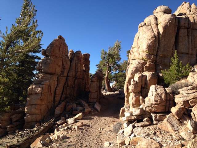
The trail mercifully flattened out (only because there was nowhere else to climb at the moment) and, after passing through an ancient granite "gate" descended to a broad gravely saddle where we made camp for the night at 11,000 feet. 

Morning dawned chilly, but warmed up as soon as the sun peaked over the eastern crests. We enjoyed the views from our high saddle and again set off down the trail with considerably more spring in our steps than the previous two days. Perhaps we were finally acclimating to our new packs and the altitude. 

The discussions that day revolved around the logistics of adding a day to this section to summit Mt. Whitney with our available supplies. The high Sierra is considerably more remote than any of the previous 700 miles. Resupply is not as easy as simply hitching out at the nearest road - the nearest road is often eight miles away and over a 13,000 foot pass! 

We watered at Diaz Creek where tiny alpine hermit crabs with shells made of glued sand grains scurried along the bottom of the shallow creek. 

The trail climbed away from Diaz Creek and over several small ridges where the formerly distant peaks of the high Sierra - grey jagged teeth far off on the horizon for the past two weeks - now seemed close enough to touch. Steadily we ascended toward a massive bald peak, the Lodgepole and other pines giving way to gnarled Foxtail pines as we approached the timberline. We paused at Chicken Spring Lake for a rest, our first Sierran Lake and only the third lake of the entire trail so far. The still blue water reflected the steep glacier-carved bowl it filled. Above, the omnipresent fighter jets burned up our tax dollars joyriding over this most scenic landscape. I couldn't blame them one bit -- I would be doing the exact same thing if given the opportunity. 


We crossed into Sequoia National Park at 11,200 feet and camped in a small meadow as the sun set behind the craggy range to the west.  

After our discussions of the previous days, we decided that it was possible to summit Whitney and make our scheduled resupply without starving to death. To this end we set off the next morning, descending to cross a large creek where we rested in the shade while a mule skinner coaxed his laden animals across and up the opposite bank. 

Again the trail climbed above the timberline and then rapidly descended a rough and bouldered set of switchbacks into a steep-sided granite canyon. Exhausted by the climb and the subsequent treacherous descent, we took a short break under a huge Foxtail pine before resuming the trail as it climbed the canyon under ever more majestic peaks. Within a mile we came upon a sign marking the Whitney Spur trail, which we followed past a babbling brook filled with so many trout you could walk across on their backs without getting wet. 

The trail followed the stream into the most picturesque meadow either of us had ever seen. Birds sang in key with the brook and the mountains gazed on benevolently from the impossibly blue skies. A pair of deer grazed completely unafraid only feet from the trail. Disney could not have composed a more idyllic scene.

The trail climbed steadily and at times steeply towards the high peaks of the Whitney group. The feeling of the vastness of the mountains is almost impossible to describe in words and is even more futile to capture accurately in a picture. We were as joyful as we had been in days, smiling at every step and turn of the trail, each moment a gift that made the physical effort easy.


Up and up we walked, deeper into the great glacial valley surrounded by these massive peaks. Soon even the Foxtail pines couldn't take the altitude and disappeared, leaving only hardy meadow grasses and moss to add splashes of green to the immense grey and blue panorama. 

Guitar Lake teemed with would-be summiteers and a fairground of tents. Seeking a more serene setting for our camp, we followed the trail a little higher over then next rise and were rewarded with a pristine lake and meadow completely to ourselves. Below, the circus at Guitar Lake was close enough to be audible, but for some reason not one other person had thought to hike another ten minutes up the hill to escape the cacophony.  

This was our highest camp yet at 11,700 feet, and by far the most scenic. We even had an infinity pool overlooking distant sawtooth peaks. 


Being more possessed than my wife of that spark which drives people to summit high peaks, I would be making my summit attempt alone. I awoke at 4:30 the next morning and escaped the siren call of my warm sleeping bag into the chill predawn air. The headlamps of sunrise summiteers bobbed along the switchbacks thousands of feet above as the first gray of dawn lighted the sky. After a hearty breakfast and coffee, I set off up the trail with a small daypack. My steps were light and fast without fifty pounds on my back, but I soon found myself winded by the thin air and the steep switchbacks. After a mile the grade slacked a little and I found a comfortable pace. Higher and higher I climbed up the east face of the Whitney/Muir crest. Soon I was looking down on the peaks of Mt. Hitchcock, which that morning had seemed to tower impossibly over the campsite. The summit of Whitney was still out of sight and two thousand vertical feet away. Far below, the Hitchcock Lakes were black bottomless pools. 

I rounded a switchback and paused to catch my breath just as the first sun rays kissed the top of the distant sawtooth peaks. I lost my breath all over again. The monumental grandeur of the vision was like looking into the face of God, and all I could do was laugh like a fool with the elation of it. 

Apropos of nothing, the poem "Ozymandias" came to mind, as if my brain was trying to find words for the wordless beauty before me, and coming up empty, borrowed Shelley's perfect poem as a poor substitute. 

When I regained my senses, I tackled the climb with a renewed vigor. Above 13,500 feet, snow and ice covered parts of the narrow, treacherous path and the going slowed as I concentrated on not tumbling off of mountain. The sky was considerably lighter when I reached the sharp ridge crest that I would follow up to the summit. Stepping out from behind a large granite needle I was greeted by the palm-tingling sight of the three-foot wide path perched on the three-foot wide crest, with a 10,000 foot drop to Owens Valley to the east and a 3,000 foot drop to the valley on the west. 


In the thin air my concentration began to wander dangerously, and I had to consciously focus on the icy path. Twisting an ankle here would be highly problematic. 

At 7:30am, two hours after I left camp, I stood on the 14,505 foot peak of the tallest mountain in the continental United States. Owens and Jenkins peaks stood off in the sunlight to the south - we had passed just under those weeks ago at Walker Pass. Beyond them in the infinite gray was the barely perceptible darker gray of the San Bernardinos and the Angeles Crest. Beyond even that, and supposedly visible on exceptionally clear days, was the peak of Mt. San Jacinto, some 211 miles away as the crow flies (and 583 trail miles!). To the north lay countless more peaks under which we would be passing in the coming weeks. After signing the register and snapping a few pictures, I took one last look and headed back down the hill.
 

An hour and a half later, I reached our campsite where Alyssa had been busy with camp chores and watching the Marmots play and fight in the meadow. I had just made a +-3,000 foot, eight mile round trip, but now it was time for the day's hike to Forester Pass, fifteen miles away. 

Down we climbed from our perch beneath Whitney and rejoined the PCT, which is also the John Muir Trail for the next two hundred miles. Turning north we hiked right at the tree line, dipping into forests as the trail descended into creek valleys and out into the barrens again as we regaining the ridgelines. After crossing Tyndall Creek the trail ascended steadily up a treeless plateau that afforded humbling views of the surrounding peaks. As the trail turned east toward a sheer wall and huge glacial canyon, we strained to see where Forester "Pass" might be. Finally we reached the foot of the switchbacks that led up to the pass, where we found a barely large enough campsite amongst the boulders and tarn lakes. 

If you were under the impression that a pass is a low point between two peaks, then you will agree with us that Forester Pass is inappropriately named. The "pass" is a notch in the granite 13,200 feet up on a snow-encrusted ridge. The trail up to it had to be blasted into the living rock with dynamite, as it is essentially a sheer face. 

We climbed this trail first thing the next morning. With fresh lungs and legs we completed the mile-long 700 foot ascent in about 45 minutes. Cresting the notch revealed a huge cirque surrounded by 14,000 foot peaks, which steeply graded into a mile-wide glacial valley that bent away into the distance: welcome to Kings Canyon National Park. Down and down the steep cobble trail we hiked, finally reaching the tree line at 11,500 feet, passing above shockingly blue tarn lakes that turned to a million brilliant diamonds with every slight breeze.


Farther into the vast valley we went, the forest returning and the smell of sweet pine replacing the arid dryness of the higher elevations. Pausing by a small creek, we swatted mosquitos and ate most of our remaining food. The trail followed large Bubb's Creek along the valley floor where we were tempted by perfect riverside camp spots to delay our exit from the wilderness another day, but our nonexistent food supply spurred us on. 

After a couple of miles of steady descent the trail abruptly turned right and steeply up. After so many miles and so much climbing over the last three days, the change was unwelcome. Our backs and legs burned as we began regaining much of the altitude we had just given up. Adding to to the unpleasantness was the steepness of the grade, which was far greater than the fifteen percent mandated by Congress for the PCT. Up and up we climbed out of the Center Basin and into Kearsarge Valley. There we turned off the PCT onto the Kearsarge Pass trail, which would take us out to Onion Valley where we could hitch a ride into Independence to pick up our resupply box. Up and up Kearsarge Valley we climbed towards Kearsarge Pass, another misnamed notch in a granite wall. The grade and sun were relentless, and our patience and energy were rapidly running out. At long last we reached the 11,700 foot summit of the slippery, bouldery trail and passed from King's Canyon National Park into the John Muir Wilderness and renewed views of the Owens Valley. Instantly, the awful, steep, rutted trail we had been cursing turned into a broad, beautifully maintained path coursing gently down the Onion Valley. Downhill on such a path is easy hiking, and we completed the five miles to the campground with twice the speed we could muster climbing up. 

Our hitchhiking karma was good, as we almost immediately found a ride into town. We headed to Lone Pine, some thirty miles down the road, where we found a hostel, showers and freshly cooked (not rehydrated) food.

Monday morning we'll hitch back to Independence to get our resupply box, and then hitch the thirteen miles up the Onion Valley to re-cross the Kearsarge Pass again and regain the trail. Hopefully the day off will have rejuvenated us enough to complete the 2,500 foot, five mile climb. From there we tackle the rest of the high Sierra, and we won't exit the trail again for several weeks. The toughest climbs are behind us, and now we have the confidence and conditioning to tackle those to come, one step at a time.  


Saturday, June 13, 2015

Out of the Desert... PSYCH!

Mojave vs. Tehachapi, Tehachapi vs. Mojave... This debate consumes hikers for miles as they approach Willow Springs Road (or Highway 58, for those interested in an additional eight waterless and shadeless miles). The relative merits of each are discussed and weighed against the other in heated exchanges at camps and springs in the forty miles before the highway.  Whispers of an all-you-can-eat Chinese Buffet in Tehachapi entice many to this town with better amenities but more sprawl. Word of a $36/night Motel 6 in Mojave lures more to this walkable but less well-appointed blip on the map.

We stayed the first night at the Tehachapi airport, a tiny airfield where pilots have to radio each other on a designated frequency because there isn't an ATC tower. The airport is "PCT Hiker Friendly",  a magic phrase that means cheap food, cheap lodging, and if you're lucky, showers. Hikers get to use the pilot's lounge and camp in a small grassy park onsite for only $5 a night. The lounge's La-Z-Boys are constantly occupied, the room's television turning hikers into transfixed unblinking zombies. A local woman drops off food for the hikers every day of the week, and every night at 3am the sprinklers come on to give your tent a wash (included in the price!). How could we pass up such a deal?

Jan's stepdad arrived the next day with hotel reservations for us and a promise of sushi dinner. In the meantime, there was a bakery that needed extensive investigation on Alyssa's part for, uh, professional reasons. (Note: Kohnen's Country Bakery is excellent. Get the boysenberry danish before they sell out, a mug for your bottomless coffee, and a chocolate chunk cookie to-go). So with full bellies and after an outrageous soak in the jacuzzi tub in our hotel bedroom, we were ready to slam out the much-maligned "Section F": eighty-five miles of uncertain-to-no-water sources.

After a long, lazy breakfast at Kohnen's, Bent dropped us off at the trail where it intersects Highway 58. We began our trek through dry grass and Joshua Trees, the path easy and level as it paralleled the highway. Wind turbines on the surrounding crests keeping a smug eye on us, we turned left sharply and the switchbacks began. The switchbacks...and the wind. Up and up we toiled, the wind intensifying to gale force across some of the passes. What plants that managed to grow were flattened against the ground by the constant howl. The occasional cheeky pinyon pine stood (relatively) tall in defiance, and we crested a ridge to find a patch of them forming a perfect windbreak for snack time. As we climbed further up and made our way northeast, the desert transformed into oak and pine. We hiked until we hit our first water resource of Section F, Golden Oaks Spring. Like a watering hole on the African Savannah, all manner of strange species gathered near the life-sustaining spring making strange noises and waiting for their turn. After refilling our water to capacity we hiked on, determined to finish our scheduled twenty-two miles that day. Just before sunset we found a camp site near some old wind turbines in the welcome shade of a pine tree.

The next day dawned gloomy and overcast, and the normally white wind turbine blades turned a hue of eggshell blue in the strange light. We packed up camp and set off, keeping a watchful eye on the clouds in case some rain might chance to break the stifling humidity. Crossing through terrain dominated by oaks and cow pies (with only one unseen cow lowing from her hilltop), we climbed higher and higher until we reached Landers Meadow. It was heart-swelling in its likeness to a bona-fide Sierra meadow: lush open greenery hemmed in by tall pines. We tramped happily off-trail to Landers Spring, a delightfully clear and abundant piped spring at the top of a small meadow. We set up camp amid granite boulder piles, luxuriating in the soft pine needle beds and cool climate. Between us and the next reliable water source lay forty-five hot, dry miles of arid semi-desert. Fortunately for us and our little group of fellow travelers, Alyssa's parents had decided to conjure up more trail magic at Bird Spring Pass, about halfway through the extended dry section. Before setting off the following morning, Alyssa made sure everyone around camp knew there would be water at Bird Spring Pass the morning after next. 

Again we filled our water to capacity and set off. Less than five miles later, our shade cover had disappeared completely and clear skies blazed down on us. Wait a minute! What happened to the trees? The meadow? Why were we suddenly looking at barren brown hills dotted with Joshua Trees again?! Lamenting the return to the desert, we pushed down a ravine as the day heated up, passing Kelso Valley Road and an unexpected water cache. Having conserved our water thus far we didn't fill up, leaving the small cache for someone who really needed it. The day proved long, hot, and difficult. Old mining roads, cars, and equipment rusted in the sun at intervals along the route, testament to the area's historical use. Our afternoon break was spent under a generous Joshua Tree as a few late afternoon clouds passed overhead. We didn't dally in the shade too long, as the constant awareness of miles left to walk ousted us back onto our feet almost as soon as our sweat-soaked shirts had started to dry. We managed to get to the crossing of Bird Spring Pass at the end of the day, where we put up the tent under the shelter of a pinyon pine and relished in a sunset that only the desert can produce.


Jan's 35th Birthday dawned with clear skies and the promise of fresh provisions. We made our way a few steps down to the road and amongst the tents of our hiker bubble tucked against granite boulders and under pinyons. We made some instant coffee and shared a package of PopTarts to pass the time while waiting for Alyssa's parents. They arrived promptly at 7:30am. Hugs were dispensed first, water second. While Alyssa's dad chatted up our gang, Alyssa's mom set up a card table and camping chairs in the shade of the truck. The spread started out with birthday cake, cookies, fresh fruit, pitted dates, and sodas. A round of "Happy Birthday" to Jan and a couple pieces of cake later, we burned off the sugar rush climbing 2000 feet in four miles. Yet again, the Joshua Trees made way for pinyon pines and oaks, except this time the shade wasn't as vital as usual. Unlike the past few days' timid clouds, thick blankets of gray floated heavily overhead. We were afforded clearer views of the storm clouds as we climbed higher onto the plateau. The trail turned onto a jeep track, each rut and undulation deepening our irritation with the lazy route planning. With a bit of thunder booming in the distance, we wound across the equally moody plain and had to step off the trail from time to time, yielding to Jeeps and motorbikes. It was as the last motorbike left us in a wake of exhaust fumes that the thunder pealed directly overhead. Footsteps later, big fat raindrops dampened the dusty road and we realized that the rain curtains had become uncomfortably close and all around us. As soon as the trail left the Jeep track and resumed a proper tread, the thunderstorm gave us a good flash of lightning with an immediate resonant boom of thunder. Point taken! Considering our position on the high end of the plateau and the lack of cover, we took quick action. Downwind of the storm, we sheltered beside a granite boulder and put up the tent. Rain steadily fell as we tossed our backpacks and boots in the tent, crawled in with them, and waited. The hiking had made us sweaty, the storm had made us steamy, so we napped in an uncomfortable enclosed damp stink while the thunder and rain continued overhead. An hour later, the storm had cleared to the south so we packed up our wet tent and shouldered our packs. By now it was 5:00pm and we still had almost eight miles to go until we reached our goal for the day. Time to book it! Managing a swift pace aided by the gentle descent, we fairly jogged down the side of the canyon to make Walker Pass campground before dark. The clearing skies and late afternoon sun cast the trail, pinyons, and oaks into a warm post-storm glow. We arrived at the campground tired but triumphant, and to the cheers of a welcoming committee of our fellow hikers. Some Trail Magic had arrived and Jan was handed a celebratory birthday beer. With the help of a rare campfire and conversation with other hikers, we managed to stay up past 9:00pm to enjoy the success of completing Section F.


Here is where having low expectations often beats having high expectations. Section F was hard because of the scarcity of reliable water sources, but it was also surprisingly beautiful, which made for some excellent hiking. We expected the worst and were pleasantly surprised when it turned out to not be all that bad. Section G contains Kennedy Meadows and the start of the Sierras, so when we set out from Walker Pass the following morning it was with a skip in our step, knowing that the desert was officially over. How terribly WRONG we were. What followed was two days of the desert in disguise and a potpourri of curse words directed at the trail. The forests of pine and oak thinned to the point of uselessness and the temperature kept rising. We were sweating more than we had in any of the proper desert sections. For two days we took turns complaining about the stifling weather and the lack of anything that felt like the Sierra, despite the geological fact that we were, indeed, in the Sierra. Unfortunately, the southeastern side next to the Mojave desert and the south end of Owens Valley is more like the desert and less like the mountains, even though we were trekking between 5,000 and 8,000 feet. 


We traversed around Owen's Peak, a scraggly white granite mass that certainly looked like it belonged to the Sierras. The trail dipped down to Spanish Needle Creek and back up a painfully hot and steep slope. We made camp three miles beyond the creek when the narrow steep trail finally relented at the crest of a saddle. The next day we climbed up Bear Mountain, an area which suffered a major fire in the early 2000s from which it never recovered. This was the moment we had been waiting for, as Mt. Whitney and the high Sierra came into the distant view as we reached the end of the six mile climb. As we descended to Manter Creek, masses of Flannel Bush with its cheery yellow flowers struck an exceptionally bright note in the setting sun. We made camp in the broad valley at Manter Creek,  the sharp granite needles and fins of Dome Lands Wilderness to the West and Sequoia National Forest to Northeast. With only ten miles remaining to Kennedy Meadows (what all hikers consider to be the proper start of the Sierras), we knew the desert was actually, seriously, for real this time, behind us.


The next morning, most of our contingent were smelling the barn and were already on the trail by the time we woke up at 6:30am. We were greeted with a cheery "Happy Kennedy Meadows Day!" instead of "Good Morning" while we ate our oatmeal. Our seventh straight day on the trail was made easy by an almost-level trail, cloudy cool weather, and the knowledge that in a few short hours we would be at the Kennedy Meadows General Store.

Alyssa's parents were waiting at the store amongst the twenty or thirty hikers enjoying the patio, hamburgers, and refreshments. Gear and resupply boxes were scattered everywhere, and the mood was buoyant with everyone happy to have finally reached this milestone.

We said our farewells and climbed into the truck for the drive back to Simi Valley for some time off the trail for a wedding, all the food and drink we have been dreaming of, water that doesn't need to be filtered, and a few hundred bucks of new gear.  We'll enjoy the rest, but come Sunday we will be back at Kennedy Meadows, refreshed and ready to take on the Sierras, one step at a time.

Saturday, May 30, 2015

Big Bear to Tehachapi, the long way

The promised storm that drove us off the trail in Big Bear fizzled, despite the breathless expectations of network weathermen and the caravan of news vans parked on Main Street early in the morning hoping to get footage of the great May blizzard for the 8 o'clock news.  We took a "zero day" anyhow, cozy-ing up in our hotel room and rotting  our minds with garbage TV.

The next day dawned clear and cold, and after one last cup of coffee we hit the trail again. Up we climbed, around Big Bear Lake to the northwest, following the San Bernardinos westerly. The cold air and easy climbs made for fast walking and we hiked the twenty miles to Holcomb Creek by mid afternoon, where we camped on a cushion of pine needles. 

The next morning we lingered in the tent a little longer than normal on account of the chill, but by 8:30 we were back on the trail continuing our tour of the San Bernardinos. The trail continued to drop from the alpine zone into high-desert chaparral and pinyon groves as we approached the Mojave side of the range. Soon we were walking on a steep and shaley path above Deep Creek, a large stream in the eastern San Bernadinos that eventually flows into the Mojave River. We crossed a couple of beautifully built foot bridges high above the Cottonwood and Oak shaded creek, the trail being perched obnoxiously high up the steep, exposed canyon wall above the shaded stream bed.  After our customary twenty miles, we found a suitable campsite in a dry tributary creek bed. The decomposed granite was soft and warm from the afternoon sun, a perfect place to put up a tent. 

Early the next day we passed the hot spring at which we had opted not to camp the night before on account of it being the weekend and us having a low tolerance for hippies, especially naked ones. The trail climbed higher up the canyon wall while Deep Creek flowed contentedly and coolly below.  We rounded a bend to be greeted with a view of Victorville and a huge Army Corps of Engineers dam that was built to control flooding at the confluence of Deep And Mojave Creeks. 

We had lunch on a shaded sand bank below the dam before climbing again to follow an oak covered ridge. The constant sound of unseen freight trains were an appropriate soundtrack as we steadily climbed and descended, in and out of every ravine and contour, as is the usual tradition of the PCT. After ten-ish miles the trail dropped back into the valley and came to the foot of another massive earthen dam which holds back Lake Silverwood. We were beginning to run low on water, but despite the proximity of the lake, there was no water available, so we were forced to press on. Around the lake the trail twisted, tantalizingly close but so far away from the unavailable water. Finally, as a chill fog began to move in, we exhaustedly set our packs down at the Cleghorn day use area, twenty four miles later and completely out of gas. 

We slept in an extra hour and a half the next morning, finally willing our tired feet and backs to resume the work ahead of us. The promise of McDonald's beckoned us along, climbing out of the chaparral and up onto the badlands above the massive interstate and rail works that fill the Cajon Pass. The sound of train horns and traffic were constant as we descended slippery sandy slopes into a small canyon, and eventually passing an old bridge footing (old Route 66!) and a sign saying "McDonald's .4 miles". We leaned our packs next to about fifteen others and hurried inside for our reward. Stuffed full of fries, a hot fudge sundae and an Oreo McFlurry, we topped off on water and determined to put down another five miles that afternoon. Under Interstate 15 and over the Union Pacific tracks we walked, past Mormon Rocks and up and over into the San Andreas fault valley.

After a tight camp in a tiny seasonal creek bed we quickly crossed the fault valley and began a long and at times steep ascent into the San Gabriel mountains. Up and up we climbed all morning and into the afternoon, finally leveling off at about 8,000 feet. Again driven by the lack of water along the route, we forced our tired legs to carry us all the way to Guffy Campground some 6,000 feet above where we started and twenty miles on. There, we spent a freezing cold and windy night; down bags and longjohns barely keeping the chill air at bay. 

We resumed again a little later than normal due to the difficulty of getting out of a (finally) warm sleeping bag. The trail further wound along the crest of the San Gabriels, sometimes offering expansive views of the Mojave Desert far below, sometimes of the limitless cloud tops stretching west over Riverside and Los Angeles Counties. After a short nine or so miles we reached the first crossing of Highway 2 at Inspiration Point. Alyssa's parents were waiting there to drive us down the hill to Wrightwood for resupply, beer, and pizza. 

There being no laundromat in Wrightwood, we called around until we found a trail angel who let us use his washer and dryer while David (Alyssa's father) and I made small talk with him in his living room. 

The weather report called for a chance of snow the next day, so most hikers who were in town decided to stay. Not us. We bid the parents goodbye at the turnout and resumed the trail as it descended slightly for a few miles and then began switch-backing up Mount Baden-Powell. Visibility was zero in the thick, wet clouds as we climbed ever higher, hoping that at some point we would break through and be rewarded with Baden-Powell's famous views. Unfortunately, the fog showed no sign of thinning as we approached the 9,399 foot summit. With no reason to linger in the damp whiteout we pressed on, downhill this time, making a cold, damp camp at Little Jimmy campground just before the first of the Memorial Weekend campers began streaming in. 

Early to bed, early to rise, we continued our trek through the San Gabriels, making several gratuitous 1,000 foot ascents up to ridgelines affording the same cloudy views as before, only to switchback down the other side back to the road less than a mile from where we left it.  Part of the trail in this section is closed to protect the critically endangered Yellow Legged Mountain Frog, so we were forced onto the shoulder of Highway 2 for an exciting four mile road walk; dodging holiday drivers speeding around the inviting twists and turns of the Angeles Crest Highway. A few miles after rejoining the trail proper, we met up with some trail friends at a flat spot on a ridgeline, the only suitable camping spot for several miles. The omnipresent damp clouds cleared just long enough for us to enjoy our dinner and the sunset before blowing in again just as we zipped up our tents. 

The next day dawned clear, but our tents were soaked, so we packed everything up still wet in the hopes of drying it at lunch. More switchbacks, the scenery alternating between pines and chapparal. 

Soon the trees began to seem especially thin and the undergrowth especially thick, and we soon realized that we were in the middle of the worst of the 2009 Station Fire burned area. Even the Sequoias, ever resistant to wildfire, were burnt to a cinder. Leaking out of the stump of one tree I found a stream of lead -- some hunter's wayward bullet melted out of its tree by the intense heat of the fire. We missed our intended camping spot and wound up camping on a saddle next to Mt. Gleason Road with about ten other hikers who had also been unable to find Big Buck campground. The clouds had finally burned off for good, and we had our first real views of the Angeles Crest from our vantage high on the flanks of Mt. Gleason. 

The trail climbed up and over the summit of Mt. Gleason; formely a Nike missile installation, then a Junior Conservation Camp, now returned to nature by the fire. Views of the Mojave to the east and the Santa Monica Mountains far to the west greeted us as we descended further down through the burn area. Down and down we stepped, stopping at a ranger station for lunch and water, then climbing a small ridge and then again down and west towards the town of Acton and our next resupply. 

Just off the trail, Acton KOA offers showers, laundry, camping, a convenience store, and a swimming pool. This being Memorial Day afternoon, the departing weekend campers had donated all their leftover beer and food to the PCT hikers who had congregated under a white gazebo on the far side of the campground. Unfortunately, most of this bounty had been devoured by the time we hiked in, so we ordered pizza and beer (beer delivery!!!) and enjoyed our first warm evening in a week talking to our fellow hikers. 

The next morning, after sleeping in all the way until 7:30, I hitched into town to get our resupply box, then hitched back. We were in no hurry as we only planned to hike just past Agua Dulce that day, a relatively flat fourteen miles or so. We set out at about noon to a pleasant breeze, passing the marker commemorating the dedication of the PCT in 1993, and winding our way up into the hills towards Interstate 14. After about ten miles we passed through a small tunnel under the interstate and were soon walking through the cool canyons formed by the towering tilted red  sandstone of the Vasquez Rocks themselves. You've probably seen them in a movie or a commercial - they were where Kirk fought Gorn. 


Alyssa's parents had decided to dip their toes in the Trail Angel game and had set up a little trail magic table at the Vasquez Rocks Day Use Area. We stopped for a few hours to visit and eat some fresh fruit before heading out again, following the trail through the middle of the small town of Agua Dulce, past a huge junk/prop yard which included the entire fuselage of a Boeing 707, and up into the Sierra Pelona range. We camped on the shoulders of broad Mint Canyon surrounded by California Buckwheat and Yerba Santa.

The next day dawned warm and only heated up further as we trudged through endless miles of steeply pitched trails lined by shadeless chapparal. Up the Sierra Pelona we climbed and sweated, then descended the north side where dense Black and Interior Live Oaks brought shade and also swarms of flies. The heat continued unabated as we crossed a small highway in the bottom of a valley and began climbing the even hotter and steeper southwest flank of the Leona Divide. Exhausted and overheated, we found a rare bit of shade under a gnarled scrub oak and rested for an hour before setting off again, ever watchful on our dwindling water supplies. 

After diving in and out of innumerable canyons and ravines, the trail at last dropped us onto San Francisquito Rd. and the first water in fifteen blazing miles. 

We camped by the highway under spreading pines that night, determined to get an early start on yet another fire-caused detour (2013 Powerhouse Fire) which would require a twelve mile road march through the tiny town of Lake Hughes. 

The cool morning helped speed us on, and we were clear of the blasted highway and back on the trail before it got too hot.  The clouds of black flies had only intensified since we first encountered them the day before, and as we climbed back into the hills to rejoin the trail they were a constant nuisance. No matter how many we ingested they simply wouldn't heed the warning. A thousand vertical feet later we set up camp at oak shaded Sawmill Campground and I (Jan) set off in search of a supposed water source that was "not too far" from the campground. After a half a mile uphill and a half-hour spent bush-whacking through waist-high grass and mustard, I found the water tank and refilled our empty bottles. The flies by now had invited their mosquito brethren to the party. Eating at a picnic table instead of sitting on the ground was a nice change in spite of the buzzing invaders, but after dinner we retreated to the protection of our tent in anticipation of another early start. 

The last hike of the Angeles Crest section dawned cool as we set off down the Leona Divide towards the Liebre Mountains. After a short but steep ascent we were finally rewarded with a view worthy of the climb. To the south and east the San Gabriels and all the peaks and ranges we had scaled the previous week and a half were visible. The roller coasters of Magic Mountain lay below the 14 Freeway pass and beyond that lay the Valley and Los Angeles. To the southwest, the spine of Santa Monicas stood tall before abruptly ending in a brilliant white haze marking the Pacific Ocean at Pt. Mugu. 


This was the highlight of the day's hike. What followed was a hot, waterless, humorless switchback descent into the very maw of hell. We now discovered where all the biting flies were coming from -- Beelzebub's seat of power, Lancaster, CA. 

Due to disputes between Tejon Ranch and the feds, the PCT has been "temporarily" routed (since the 1980's) down off of the scenic pacific crest and into the Antelope Valley for a 30+ mile crossing of the hot, airless valley floor, where temperatures regularly reach into the 100's. The beginning of this detour is a too-steep descent along a poor jeep trail which then turns into a poorly maintained foot trail that alternates maddeningly between gratuitous steep climbs and useless switchbacks. Many a hiker who has come this way on a hot afternoon has cursed Tejon Ranch and the Forest Service out loud and in tongues.  

After the longest four mile walk of my entire life, the trail turned onto a straight dirt road and directly (finally) towards our destination: Hiker Town. 

Despite what it sounds like, there is no Thunderdome in Hikertown, and also no Tina Turner in bondage gear.


It is basically a two acre plot of land on Highway 138 that has a spigot, a house, a dog, and about eight roosters. The owner lets PCT hikers shower and hide from the heat of the day in his converted garage, and he also accepts resupply packages. It is a funky but welcome resupply point on an otherwise barren and altogether frustrating section of trail. 

From Hikertown the trail follows California Aqueduct access roads across twenty miles of shadeless valley. It is neither a crest, nor is is scenic. It is reviled by most PCT hikers. On hot days it can become virtually impassable. Thus, the smart hiker waits out the heat at Hikertown and begins this boring and potentially dangerous section in the late afternoon. 

We set out six PM, and as the sun set behind the mountains with the waxing gibbous moon climbing overhead, the valley almost looked pretty. The route was plenty boring, but without heat to contend with it went by quickly. A coffee break at nine PM was followed by a refreshing beer at about 10:30 as we came upon a group of hikers towing a wagon with a full cooler. This was the best trail magic so far. 

After twenty miles we had had enough, and fell into our tent for a few hours of sleep. We awoke in the middle of a windfarm at five in the morning. The air was absolutely still and hot even before the sun had peeked above the nearby ridgeline. We determined to hike the remaining five miles to Tylerhorse Canyon where we would re-water and set up in the shade to wait out what promised to be another hot day. 

We passed about six hours under a makeshift sunshelter composed of the tarp, a couple of trekking poles, and some para cord. A breeze picked up at about two, and at three, out of sheer boredom, we shouldered our packs again. 

Low on energy after the sleepless night and sweltering morning, we trudged up some nameless mountains, wondering why in the hell we were doing this. After dinner and whiskey we felt a little better, but exhaustion finally forced us off the trail and into a deep sleep before we had gone even a couple more miles. 

The alarm sounded early the next morning and I immediately turned it off. We needed sleep more than we needed to hurry onto the trail. Besides, at this altitude the heat wasn't so bad and a nice breeze was blowing from the west. We slept in until it was too light to ignore the day anymore, then sipped hot chocolate and enjoyed the view of the sunrise and the Antelope valley from our ridge top campsite before hefting our packs again for the nine-ish miles to Willow Springs Road, where we planned to hitchhike into Tehachapi for a couple days of rest and relaxation. 

It was either the cooler temperatures, the extra sleep, or the promise of a shower and cold beverages, but Alyssa averaged about four miles an hour while I trudged far behind, trying to keep up. Passing just beneath row upon row of whooshing wind machines we came upon the road and were picked up by the third car that passed. 

For now we are enjoying coffee and not walking, but also contemplating wearily (and warily) the next 160 miles of trail, which are the most waterless of the entire PCT. The weather is forecast to be cooler, but there are two waterless stretches over thirty-five miles long coming up. This means either more night walks on narrow trails, or carrying ten extra pounds of water, neither which option is paticularly palatable. 

That's all that lies between us and the Sierra Nevadas. It's a formidable challenge, but we'll take it on and beat it just like we did the Lagunas, San Jacintos, San Gorgonios, San Bernardinos, San Gabriels, the Angeles Crest, and the Antelope Valley: one step at a time. 


Thursday, May 28, 2015

You Don't Know Until You Know

James "Hardy" from Iowa had never been camping or backpacking before, but had made a New Years resolution to do the PCT. He started the hike at the Southern Terminus with a seventy pound backpack and a bear-proof canister, not knowing how utterly unnecessary all that heavy kit was. He quickly pared down his pack to only the essentials and was easily covering 20 miles a day. Within a week he was indistinguishable from any other seasoned hiker on the trail.

It goes to show that no amount of training, experience, or knowledge can really prepare you for the trail. The trail is the only thing that teaches you what you need to know about the trail.

Here are some things the trail has taught us:

Pain Tolerance - Everyone will discover new injuries, pains, and rashes that only come up when hiking many miles a day for days on end. Something we quickly learned is that the pain and fatigue never really stop. Aches and pains rotate, sore spots come and go. Rest helps diminish the intensity, but only a few footsteps bring a fresh reminder of every previous mile walked. What changes is how much you notice it.

R&R - The constant ache is made up for by how extraordinarily restful resting is. Twice a day (at least) we unshoulder our packs, lay out the tarp, take off our boots and socks and lay down on our backs. More often than not we're napping within minutes. The relaxation that comes after enduring physical exertion while in the peace of nature is supreme.


Cleanliness Is Next to Godliness - Showers and clean socks go a long way to making everything right in the world.

Gear - Like any sport that involves some kind of gear, there are enthusiasts who revel in arguing the minutia of every piece of equipment. Manufacturer, model, year, you name it.  The one thing few people discuss is the most important piece of gear and the one most often abused and neglected - your own body. The beauty of this piece of gear is that it is largely self-repairing, if given enough raw materials and rest to enact the repairs. 

Minimalism - You need less than you think you do. It takes an astonishingly small amount of water to live, a few foods to survive and even thrive on, and a cool breeze on a hot day can make your spirit soar. Comfort and happiness are pretty easy to come by when you strip away how you're are used to defining them.

"There is no such thing as bad weather, only bad gear." - FALSE. Shitty weather makes for shitty hiking. We have already hiked through snow and 100 degree heat. They both completely suck. There is zero enjoyment when you're on a forced march through extreme weather. Think about it....at home, if you have an outing planned and you wake up to a day of rain, you bag it. Out here? Not so. No amount of gear makes it fun.

HYOH (Hike Your Own Hike) - This isn't just a cute phrase, it is trail truth #1. It goes for everything: attitude, gear, speed, motivation, tolerance. As in life, doing what you want, how you want, reaps the biggest rewards. 


Friday, May 15, 2015

From 90 to 30 degrees

Palm Springs is the Las Vegas of California. Green grass, fountains, and dream seekers abound in this desert of the Coachella Valley.

After finishing our hike out of the San Jacinto mountains in the cooler morning hours, we met up with Jan's father at the intersection of the PCT and Interstate 10, near the town of Cabazon. While most hikers stay with nearby trail angels Ziggy & the Bear, we luxuriated in a Palm Springs Marriot suite courtesy of Papa Drees' elite membership. Outside, the temperature pushed into the mid-nineties. Inside, we were enjoying air conditioning, showers, guest laundry, and lounging on the sofa wearing only bath towels. As our ever-present hunger became more acute, we ventured out into the midday heat in search of sustenance. Alyssa had a hankering for something with fresh vegetables, Jan for something cold and creamy. First stop: the nearest health food store for the biggest salad they could make and a kombucha. Second stop: frozen yogurt, piled high. Third stop: requisite nap time on our California King-sized hotel bed. 

Capping off this day of recovery had us consuming top shelf margaritas with Jan's dad and enjoying live music and carnitas in the cooling evening air.  We reveled in the decadence, knowing well that the next few days promised a brutal climb out of the desert and into the San Bernardino mountains.

Without the sun streaming in and a cacophony of birdsongs for an alarm clock, a pre-dawn rise in a hotel room is not as easy as one in a tent. Nevertheless, we persevered to drag ourselves off of the clean sheets and onto the trail while the morning cool still prevailed. 

The trail wound up through the low Sonoran Desert of the San Gorgonio pass, steadily climbing up the sandy alluvial terrace and gradually bending south into the foothills of the San Bernardinos. Though the sun beat down out of a cloudless sky, the heat was tempered by a constant breeze. Up and up we curved; past an ancient windfarm on a hill, less than half the machines still turning, the rest standing mute and broken like rows of ancient idols. Here and again headless towers were twisted into grotesque shapes, testament to their catastrophic finale. 

Finally the narrow ravine opened up onto the mile-broad flood plain of Whitewater Creek. Most of the time the creek meanders sedately, no wider than a few feet and no deeper than a couple of inches, the cool waters disappearing into the sands before it reaches the desert floor. However, the breadth of the valley and the size of the boulders scattered in the channel betray the fact that the gentle stream can turn into a roaring muddy torrent in a moment's notice. Under the clear skies we weren't particularly worried about a flood, so we contented ourselves with a nap and a snack in the shade of a gnarled tree.

Up and up we climbed, out of the main channel and along a narrow ridge where strong gusts kept threatening to blow us into the ravine below. Finally we descended into Mission Creek and the first shade in ten miles. Under Cottonwoods and over the sandy cobbled creek bed we walked, tracing the valley upstream and ever higher into the mountains. After twenty miles we found a perfect creek side camp and fell off to sleep just as a bright Jupiter blinked on. 

The next morning the climb continued up Mission Creek, then up steep switchbacks as the Cottonwoods turned to Oak and Pinyon, which turned into enormous Jefferey Pine and Sequoia. Past 6,000 feet, then 7,000 feet - finally the trail levelled off at 9,000 feet. The light began to fade as the log cabins of Coon Creek Camp came into view. No sooner had we stopped moving than the chill wind cut right through our bones. We hurried through dinner and huddled into our down bags for warmth through the thirty degree night. 

The next morning dawned windy and cloudy, and the freezing cold made getting out of tent especially challenging. We finally hit the trail at eight in the morning, our goal for the day being Highway 18, another twenty miles distant. The cold and wind whipped us on as we stomped out the miles, the pines changing almost immediately to manzanita and cactus as we crossed over to the eastern flanks of the mountains. A few Joshua Trees and a bright orange and yellow Western Tanager added highlights of color to the flat light of the cloudy afternoon just as the first flurries blew in. A few miles later we reached the road - twenty miles in less than eight hours, a record pace for us. 

We hitched a ride into Big Bear Lake for our resupply box and to wait out the storm for our first "zero" day of our journey.  Cold beer and hot coffee are helping loosen sore sinews before we return to the trail in the morning, continuing our journey with a single step. 


Monday, May 11, 2015

The next hundred miles

If there are any entrepreneurial readers of this blog, here's your tip: Warner Springs doesn't have any amenities to speak of. What it does have is a seasonal swarm of locusts called PCT hikers that are voracious consumers of goods. You heard it here first.

The community center that the residents so kindly opened to serve this plague of nature-loving fools is located in a large "portable" building (if you went to school in California in the 80's and 90's, you know the type) between the town's only K-12 school and the baseball fields. "Camping Okay" beneath the two oak trees and No Alcohol permitted on the premises. The portable houses three computers, wifi (password: stayinschool), several bookshelves crammed with paperbacks, a bunch of tables, a washer/dryer, sundries store, al fresco showers out back, and Colette to run it all in the afternoons (or Mary Coletta, as she was christened about 80 years ago). There was even a mystery volunteer who baked a new type of cookie for all the hikers every day. Our lot was blessed with 13 dozen oatmeal-pecan-butterscotch. Warner Springs is clearly populated by saintly retirees that have taken this ragtag bunch under their wing (and one lech who offered to scrub Alyssa's back when she inquired about the showers). http://i.giphy.com/11q2f8tniG9Rwk.gif

A week of sweaty hiking and limited food/beverage options quickly turns to desperation, so a neighborly gent ferried a few hikers eight miles to the nearest store to procure beer, then turned his back and left us to create our own public house. We hopped the chainlink fence, stayed clear of the downed barbwire, and gathered in the non-school property dirt lot to drink some Tecate (Cinco de Mayo!). Names were exchanged, blisters counted, home states/countries listed, and friends quickly made.

We departed Warner Springs the next morning, the air significantly cooler than it had been the first five days, and clouds beginning to push in from the west. Winding our way through more Live Oak and Sycamore shaded canyons we began what was to become a ten-mile climb, eventually leaving the shady coolness of the creek bed for the exposed and dry chaparral of the higher elevations. The weather continued to cool - even in the heat of the early afternoon, the breeze had a definite bite to it. 

Some ten waterless miles after leaving the creek, we finally arrived at Mike Herrera's Place, a house perched high up in the hills and way off the grid. The Herrerra's family made their fortune manufacturing industrial-scale tortilla making machines. They built this off-the-grid house as a vacation getaway, but when they aren't using it they generously let PCT hikers use it as a stopover on an otherwise waterless and barren stretch of the trail. 

Greeted by a sign that said "hikers welcome!", we walked down a path made of mill-stones from the tortilla machinery to be hailed by other hikers and a guy at the grill asking if we wanted cheese on our burgers. Beers were in a cooler. The weather was quickly turning windier and colder, and we were promised chicken enchiladas for dinner, so we opted to stay. The promise of a warm RV to sleep in instead of a tent sealed the deal. 

The next morning dawned warm in the 80's vintage motor home, and freezing cold outside. We reluctantly put on our packs and began the day's hike. The wind hadn't abated and the temperature kept falling throughout the day. Our feet finally decided to make camp about five miles before the road (twenty miles down the trail) at the bottom of a narrow canyon. We cooked and ate dinner in the tent, the clouds racing by overhead. 

We woke up to the sound of precipitation on the rain fly, and upon closer examination discovered a layer of rime ice covering the tent. At that moment the fat snowflakes began to accumulate rapidly. 


Neither of us were looking forward to hiking (or camping) in a snowstorm, so we decided then to hike as far as the road and hitch a ride into Idyllwild. This would bypass about 20 miles of the PCT that was closed due to a 2013 fire, so we didn't see it as too big a "cheat". The only problem would be getting a ride in such awful weather. Luckily, a minivan piloted by a former thru-hiker-turned-trail-angel was waiting at the junction to take us the 18 miles into town. 

The snow was falling even more heavily when we pulled into the supermarket/post office parking lot, and the internet resources said that there were no vacancies at any of the hotels. The Internet, it turns out, is not the place to find a room in Idyllwild. A serendipitous meeting with the proprietor of the Idyllwild Gift Shop turned up a vacancy at a small place just down the road. It turns out that there isn't an app for personal communication in small mountain towns. 

The next day we began the long walk up the "hill", as the locals call it. The "hill" is 10,833 foot Mt. San Jacinto, and we intended to summit it. The melting snow had turned the trails into cold, wet marshes, which soon turned our boots into cold, wet marshes. There was so much slush all you needed was cherry syrup and a paper cone. Onwards and upwards we climbed. At 7,000 feet we broke through the blanket of clouds into brilliant sunlight. Fourteen miles, three crying spells on Alyssa's part, and 6,000 feet later, we reached the summit, tired but triumphant.  After enjoying the view of Palm Springs to the east and the unending cloud tops to the west, we hiked down a couple of miles and made camp as the sun set. 

One freezing night later, we were refreshed and ready to tackle the 20+ mile, 9,000 foot decent into the San Gorgonio pass. 

The air steadily warmed as we descended the flanks of San Jacinto. First through fir and pine forests which slowly gave way to Giant Sequoia, then scrub oak, then chaparral, and finally Sonoran desert. Through interminable switchbacks we plodded, the distances on this mountain incomprehensibly vast. We would see a landmark that appeared only 1,000 feet lower and a half-mile distant, but by the time we reached it we had walked almost four miles. Finally, exhausted, we found enough level ground to pitch our tent. The warm breeze was a welcome change as we enjoyed dinner outside for the first time in days, admiring views of the valley and the mountain peak on which we had stood the evening before.   

Ahead of us, only an arm's reach away, lay the foothills of the San Gorgonio range, our home for the next several weeks. We will get there, one step at a time. 


Tuesday, May 5, 2015

The first hundred miles


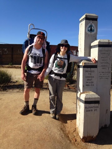
We finally got started at 8:30AM at the trailhead outside Campo, CA. The border fence was already radiating a fierce heat off of the rusted steel, even this early in the morning. 

"Well, let's go," and so we went, our 1,900 mile journey beginning with a single step. 

The pace of the first few hundred miles of the trail is governed by the scarcity of water in the desert. A healthy person requires at least one gallon per day to hike in the heat of the day, and a gallon of water  weighs about ten pounds. You can already see that carrying even enough water for only two days becomes oppressively heavy. Our first day was therefore going to be twenty miles, since this was the distance to the first water source on the PCT at Lake Morena. 

The first mile went very quickly. The next next ten reasonably quick, the next four a slog through the afternoon heat, and the last five a misery as our water ran out and the aches and pains of the day began making themselves known. 

We pulled into Lake Morena campground eleven hours later to be greeted with a "slow clap" by the hikers who had arrived before us. We made camp and ate in the dark, and fell into a fitful sleep after deciding to wake up at first light to try and beat the heat of the day. 

Day two, our goal was Mt. Laguna some 23 trail miles away. We started around seven, a little later than we wanted, and wound our way through scrub oak chaparral onto a oak-covered floodplain, eventually crossing under I-8 and beginning a very hot and sweaty climb on mostly shadeless granite slopes. It was already 85 degrees at eleven o'clock when we began looking for a place to siesta to wait out the heat of the day. We eventually came upon one of the few water sources along the route, and a majestic live oak provided shade for us as we napped underneath in the still heat. After a few hours we realized that we needed to get moving, whether we wanted to or not, and after pumping some water from the algae-slicked creek we resumed the hot airless climb up the southern flanks of Mt. Laguna. By this time all manner of heat rashes and foot blisters which had never materialized on our training hikes in temperate Bay Area winter weather began taking their toll. Our pace slowed, then slowed more. Occasional light breezes felt arctic blasts in contrast with the langourous shimmering heat. 

Soon it became apparent that we were not going to make our chosen destination before nightfall, so we aimed to camp at a small creek about four miles  short, up on the flanks on Mt. Laguna. There we camped under the Sycamore and Live Oaks, surrounded by thickets of Poison Oak. Our feet hurt every time we had to stand up, so we opted to lie down and go to sleep as soon as possible, which was just after sunset. Two days and thirty-eight miles down. 

The next morning we awoke with the birds, and decided to postpone hot food and begin hiking immediately so that we could enjoy our breakfast at Burnt Rancheria campground some four miles away. Fresh and driven by hunger, we made great time and were soon enjoying the luxuries of pit toilets, running water, and a picnic table. Our blistering pace continued as we resumed walking after breakfast, climbing north and west. Suddenly, the Jeffrey Pines gave way to a vista of the Cuahilla Valley and Colorado desert five thousand feet below us. The Salton Sea shimmered off to the east about eighty miles. To the northeast, some one hundred miles distant, Mt. San Jacinto squatted like a darker grey phantom against the gray morning haze. We would be there in another ten or so days, after crossing the five intermediate ranges and two hundred miles of desert.


The rest of the hike followed this ridge northward, the desert valleys baking off to our right, but the temperature at our altitude perfectly pleasant. Finally, twenty miles on, our energy ran out, and the last two miles were a slow foot-sore shuffle to our camp for the night at Sunrise Trailhead, the last water for nine miles. 

Again, we nursed sore feet and went to sleep with the sun as the full moon rose to keep watch over the night. 

Day four began early as usual, but with the added knowledge that water on this stretch would be scarce, the terrain steep and hot. We began our descent to the valley below, stopping for a rest at a small spring-fed water source before pressing on for the next water another nine miles on at Highway 78. Finally the trail dropped off the side of the mountain, allowing us to cross the valley to the junction of highways S2 and 78, where we made camp in a dry arroyo under the cottonwood trees. Again, we were asleep with the sun. 

Day five we began our climb up the San Felipe hills, a hot, shadeless and usually barren section of trail. This time, the weather was on our side, with high cirrus clouds keeping the sun at bay while we climbed switchback after switchback, passing stands of blooming agave, ocotillo, barrel, and cholla cactus.  From a distance the hillsides looked lifeless and Martian, but up close they were teeming with spring efflorescence. 

Fifteen or so miles on we came across the first water of the day just as the towering thunderstorms overhead began rumbling ominously. Occasionally pairs of Marine fighter jets would scream over the ridge an arms-length away and roll inverted, diving into the valley beyond. 

We camped along the trail at about mile 96, too foot sore to continue on. 

The wind and fog woke us up with a chill, a welcome contrast to the still heat that marked the first few days. Quickly we passed the one hundred mile marker as the scrub oak and Manzanita transitioned to live oak and Sycamore. At Barrel Springs, the first natural water source in 24 miles, we had oatmeal and watched a huge Tom Turkey pick through the leaf litter in search of his own breakfast. The last eight miles wound though alternating wide open pasture land and oak-shaded ravines, eventually intersecting highway 78 just south of Warner Springs.

Here is where we take our first real rest, at the community center which has been specially opened to serve hikers. 

Palomar Observatory looks down on us from a distant ridge while we enjoy hot dogs, showers, and clean laundry. Today was a short fourteen miles before lunch. Tomorrow we will be back on the trail at dawn, beginning the rest of our journey the same way we do every morning - with a single step.